OST insists on the principle of quality first, safety first, credit first and customer first, absorbs and learns from foreign advanced engineering design concept, and undertakes several slope protection projects of railways, roads and dams. OST also wins many praises from clients with excellent project quality and now concludes a set of SNS project design flow with Chinese characters over years’ practice in engineering projects.
1. Onsite survey
In the project start-up phase, personnel sent by developer, design institute, surveying and mapping unit and OST will visit the site to know about the project and determine measurement methods – if the project is of small scale with relatively simple topography, it can be measured by general measuring method (GPS precision positioning, 3D coordinate measuring machine, Total station, etc); if the project is of large-scale with complex topography and no surveyors could approach, 3D laser scanning method can be adopted.
2. Accurate measurement
When the project is small and topography is relatively simple, conventional measuring devices like GPS locator, three-dimensional coordinate measuring machine, and total station are adopted; when the project is of large scale with complex topography and surveyor could not approach, 3D laser scanning method is adopted.

UVA Laser range finder 3D laser scanner
3. Data processing
The processing work of data obtained by common method is relatively simple while the mass data gained by 3D laser scanning method needs to be processed by special data processing software and converted into visible and emulational 3D coordinate graph. The coordinate value of any points of the scanned space under non-site conditions can provide detailed topography information, largely improving the scientificity and work efficiency of slope protection design work.
4. Computational simulation
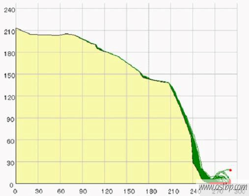
The information like slope inclination angle, height, rockfall path can be gained from rockfall section graph through 3D laser scanning. The design energy level and optimum layout location can be analyzed and calculated through rockfall path computational formula or software combined with the slope vegetation condition.

Rockfall motion path diagram
5. Layout design
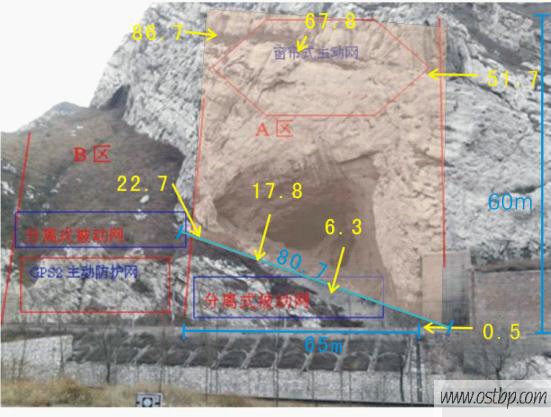
Layout design can be carried out after obtaining above-mentioned data. The division and design of protection area should follow the principle of “overcome firmness by softness, give priority to active protection, adjust measures to local conditions, segmentation and enclosure”.
The following picture is an example of layout of a certain project:

6. Product selection
OST developed over the years several series and types of slope protection products, covering active and passive protection net, and curtain-type protection net. When choosing products for project design, it should be firstly taken into consideration the requirements on rockfall protection, and then the new-type economical product.


